A Nice 70 Kilometer Bike Ride
69.2 km --- total distance
18.1 kph -- average speed
74.0 kph -- max speed
3:48 hh:mm - total time
That 74 kph was coasting down Sawmill Road between Lead Mne and Six Forks - And that amounts to only 46 mph.
I traveled down Old Lead Mine to Lead Mine then to Sawmill. I turned on Longstreet at the top of the hill and traveled to the start of 'Mine Creek Greenway'
I traveled 'Mine Creek Greenway' to Shelly Lake then on down Lead Mine Creek to where it intersects with Crabtree Creek.
Then I headed down 'Crabtree Creek' greenway all the way to the end at Anderson Point Park. I encountered two construction detours. One at the intersection of 'Crabtree Creek' greenway and I440 and the other at the greenway and Capital Blvd.
The detour at Capital Blvd required that I travel down Yonkers Road to Raleigh Road to get around 'The Swamp'. They are putting something right straight through the swamp. I joined up with the greenway where it crosses Raleigh Blvd and traveled on down to the WakeMed area and Glenburnie Drive.
The greenway from Glenburnie Drive to Anderson Point is beautiful, modern, wide and just nice.
I had my 'Lunch-PBJ' at Anderson Point Park. This reminded me of the ride back n 2004 where every day was PBJs for lunch.
Instead of fooling with all the construction detours I headed up 'The Neuse River Trail' to Fall of the Neuse Dam. I left the greenway at the new 'Falls of the Neuse' bridge and slugged up the hill on Falls of the Neuse Road and then onto Strickland Road.
The nice part of this part of the ride from the Neuse River back to home was I did not have to ride on the road very much but instead stuck to the sidewalk which lasted all the way to the Raven Ridge Intersection.
I did leave the sidewalk until Honeycutt Road where they started up again. It was then sidewalks all the way back to Forum Drive on Six Forks Road.
Here is a google maps URL that shows all the turns and such and is all set up for following the bike trails:
https://goo.gl/maps/ME5uSndSkkE2
Here is the 'embedded' map:
A nice bike ride. Here are some pictures from the ride. Here is a URL to all the pictures so you can 'swipe' through them:
Had to exit to Yonkers Rd then on to Raleigh Blvd to get back in touch with the trail.
Looks like the trail will be open again in July.
The end of Crabtree Creek Trail
Blow up of the map
The Map - Hiking, Cycling, Dog Walking, NO Horse Riding, and NO Motorcycles.
Crabtree Creek Trail T's into Neuse River Trail.
Mile 17.5 of the trail - Go left to the dam and right to Clayton.
Nice Bird Houses.
This is a nice park.
PBJs
The Rider.
Now this is handy, tools and a bike pump.
The Tool Set.
The Pump
That URL is:
http://www.dero.com/bike-repair
I wonder if they have 'chat' where they can walk you through a bike repair at one of their stations?
Here is the URL for this set of stuff:
http://www.dero.com/product/fixit/
Repair Station
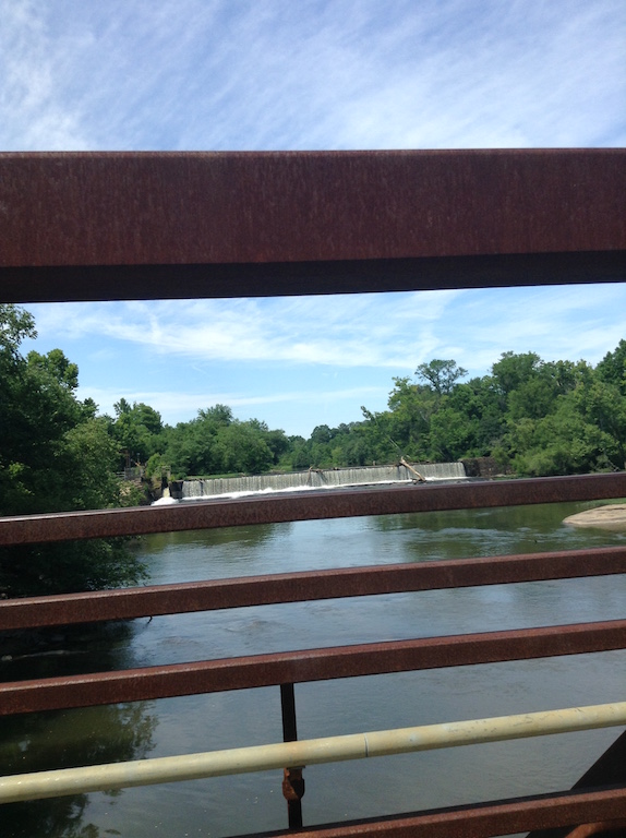
Milburnie Dam
Only a few miles from the dam.
Rest Stop a few miles from the dam.
Average HR = 114
Max HR = 141
Woah! Those are big numbers, (for me).
Nike - BURN, since I only have HR data then this essentially echos that.